Call Now 09 889 6833

Want to learn more about the products we provide?

Fill out the form with your application and requirements and we will find the right product for your needs or continue scrolling for the Product Catalog.


FARO-Nexa3D

For all your Reality Capture and Additive Manufacturing Requirements

Next-Generation Intelligent Technologies

For engineers, architects and construction professionals, acquiring the right tools can be crucial to completing a project. To meet the demands of manufacturing and industry, our leading brands are some of the most inventive and trusted names in intelligent technology.

Not only do they offer products with the highest accuracy ratings available on the market today, but their intuitive designs also make achieving desired results faster and easier than ever before, revolutionising industrial operations now and into the future.

CHCNAV Alpha3D Advanced Mobile Mapping Solution

Enquire about this product
Rent this product

Premium High-Performance Laser Scanner

Long-range scanning up to 475 m

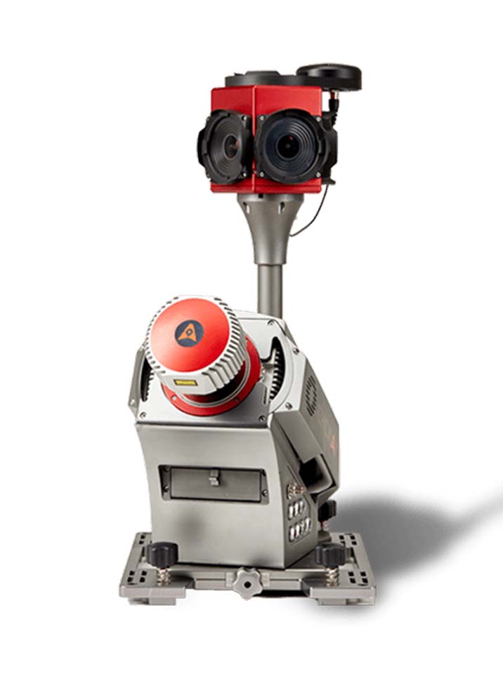
Provide high-speed scanning of 1.8 million points per second, high point cloud density even at fast driving speed and extreme quality point cloud with low range noise.

Hign Resolution 360° Images

30 MP HDR panoramic camera with superb image quality

Support fully calibrated point clouds and panorama images. You can add additional imagery sensors to get extra information whenever your application needs.

Ready now to anticipate future

Ready to add 2nd scanner for more density point clouds

Provide two RS232 ports for external device connection, 2nd GNSS antenna to work on railway or water applications, and an easy-in easy-out SSD hard disc for faster data transfer.

Vehicle Independent Platform

Easily mounted on different type of vehicles, trains, railway trolleys and boats

Whatever the task is, the Alpha3D rapidly and efficiently collects high density, accurate point clouds and powerful images data, but also adds extra information from additional sensors, such as high-resolution camera, thermal camera, GPR, echo-sounder or extra profiler.

Read More
  • Technical Specifications
  • Downloads
  • Video
  • General Performance

    • Number of Laser Scanners: Single scanner head system, optional 2nd scanner head on additional platform
    • Horizontal accuracy: < 0.030 m RMS (typical)
    • Vertical accuracy: < 0.025 m RMS (typical)
    • Accuracy conditions: Without control points, open sky conditions
    • Control unit: Internal multi-core industrial PC, low power consumption
    • Field software: CoCapture, browser-based, no installation required
    • Control interface: BYOD (any tablet or laptop), WiFi or LAN cable connection
    • Data storage: Removable 2 TB SSD hard disk with USB3 interface
    • 3rd party hardware synchronization: 1x synchronization port for 2nd GNSS antenna 2x RS232 synchronization ports (NMEA support)
    • Mounting: Vehicle independent solution, suits for road, rail and water-based application

    For details on Laser Scanner, Positioning and Imaging system capabilities please download the spec sheet.

  • CHCNAV Alpha3D