


FARO ScanPlan supports AEC Professionals by creating 2D as-built documentation, ensuring optimal scan job planning, and forming the basis for effort estimation and quotation.
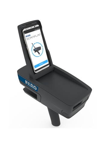
FARO ScanPlan, an innovative, handheld device that dramatically speeds up the process of capturing 2D floor plans. It is an ideal tool for anyone who needs to quickly obtain as-built floor plans of buildings for threat assessment, pre-incident planning and fire protection engineering, 2D as-built documentation, or optimal scan job planning. Use the ScanPlan to document floor plans of buildings large and small, including houses, schools, shopping malls, public venues, office buildings, construction sites, and more.
Just point and walk to capture a current 2D floor plan of any building. Control the ScanPlan with an easy-to-use smartphone application (Android or iPhone) that shows the floor plan map as it is being captured in real time. The wide-angle field of view makes it easy to map around corners, behind doors, and other hard-to-reach areas. Users can even take photographs and map multiple-story buildings, keeping the floors organized as one project. The visual interface makes it easy to confirm that everything needed to be mapped is completed before leaving the site or the building.
Bring the captured building map into FARO Zone 2D software to complete the project. Turn the floor plan into a detailed pre-incident plan or threat assessment diagram by adding photographs of critical details, standard symbols, notes, measurements, and more.
Provide stakeholders access to captured information via SCENE 2go & SCENE WebShare Cloud or Present4D VR Suite.
Easily export projects, images and documents as DXF, PDF or into a Esri Shape file for use in GIS systems, export the 2D map as point cloud into CPE, PLY and XYZ.
- Technical Specifications
- Video
-
Capture 2D Floorplans In Seconds
- Easily capture building floor plans and photographs of critical details walking through a site.
- Turn those floor plans into comprehensive, pre-incident plans with FARO Zone 2D software.
Portable and Lightweight
- At only 1.5 kg, the ScanPlan is easily carried in one hand.
Easy to Use
- Use the familiar interface of a smart phone app to control the ScanPlan and save projects.
Visualize the Floor Plan
- View the floor plan as it is being scanned so you can be confident the entire building is documented when you leave.
Further Document With Photographs
- Add photographs and annotations directly to the floor plan to document all the details of the scene.
Capture Floorplans on Multiple Floors
- Capture floor plans on multiple stories and organize them into one project.
Extended Scanning Time
- Scan for two hours one battery; easily swap in a new, charged battery and keep scanning.
Compatible With Most Smart Phones
- Use your own Android or iPhone that meet ScanPlan requirements or purchase a compatible smartphone separately.
Share Completed Projects
- Share 2D floor plans with stakeholders via SCENE 2go or by directly uploading them into SCENE WebShare Cloud.
- Optionally, in FARO Zone completed plans can be also shared via the FARO Zone Viewer application.
Easily Export and Share
- Easily export projects, images and documents as DXF, PDF or into a ESRI Shape file for use in GIS systems, export the 2D map as a point cloud into CPE, PLY and XYZ.
Find Best Positions to Place a Laser Scanner
- Scan Assist feature automatically calculates the best laser scanner positions based on the recorded 2D map.
Perform a Pre-Placement of 3D Scans on Site
- Combine the ScanPlan with laser scans and get confidence that a final scan registration will work.
- ScanPlan allows the pre-placement of single scans1.
1 Supported: FARO FOCUSS and FOCUSM scanners with firmware version 6.4 or higher
Add 360° Panoramic Images to the 2D Map
- Experience the captured space by visually walking through the panoramic images.
Explore Captured Space in Virtual Reality Mode
- Easily export the project and the panoramic images directly into present4D VR Suite for best user experience.
Additional Diagramming Software
- Bring ScanPlan floor plans into FARO Zone software to complete the diagram by adding doors, windows, stairs, alarm panels, sprinklers, utility shut-offs, dimensions, and more. FARO Zone 2D is included.
Finished Diagrams, Fast
- Generate walls automatically, use pre-drawn symbols and smart tools in FARO Zone software to quickly and easily complete your diagrams.
-
Product Downloads Section
-
FARO ScanPlan Tutorial - How to Use the Handheld Mapper
Learn how to get started with the FARO ScanPlanTM, including a walkthrough of the what is the ScanPlan, how to set up and how to do your first ScanPlan project.