

NOGGIN Adaptable GPR Systems
NOGGIN® GPR systems have been recognized by leading researchers as providing the highest quality GPR data in the world. They are also built to perform in the most demanding conditions around the globe.
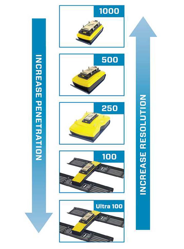
Adaptable, proven GPR for any application
Available in four centre frequencies and five standard configurations, NOGGIN® systems can collect data in any environment for any application. NOGGIN® spans the depths and resolutions required for subsurface investigations. Choose the combination of centre frequency and configuration best suited to your application and terrain.
The data collection software on the DVL 500 Noggins have default settings to get to work quickly; for line surveys just set the desired depth and start collecting. For grid collection, the GPR operator sets the grid size and line spacing. The screen prompts the user to collect each line until the grid is complete. It is easy to work around obstructions, skip lines or recollect lines if required.
Once the grid is finished (or any time after at least 3 lines have been collected), the grid data can be processed into depth slices (right in the field!).
For users involved in unusual projects, Noggins also have custom settings to collect data with extreme values:
- Depths to 200 meters (320 m in ice)
- Triggering options include Odometer, Button and Free-Run modes
- Free Run in Time or Free-Run with Speed to collect data on water, snow or ice
- Grids up to 250 x 250m in size
- Zig-zag grid collection pattern
- Step Sizes from 5 millimetres to 5 meters
- Technical Specifications
- Downloads
- Video
-
General
- Rugged by design: Noggins are used in a wide range of environments, temperatures, and weather conditions.
- Ultra-wide band (UWB) GPR antennas: Ground-coupled for maximum signal penetration and data quality.
- Digital Video Logger: High resolution, sunlight visible, resistive touch screen with Wi-Fi and USB data transfer.
- Flexible data collection: Change GPR parameters to optimize the survey. Adjust depth, step size, stacking, time window, grid size, triggering and more.
- Wi-Fi mini-reports: Email a report of line, depth slice or map view data to your customers or colleagues.
- Depth slicing: Collect grids of data and view depth slices right in the field.
- Map view: Using external GPS, display a plan map view of survey path, grids, field interpretations and flags.
- Field interpretations: dd color-coded interpretations and field flags with the touch of a finger.
- Optional GPS: Integrated GPS for post-processing and export to Google Earth™, CAD drawings & GIS databases.
- Multi-language: English, French, German, Spanish, Japanese, Simplified Chinese, Farsi, Russian, Arabic.
For more details on different frequencies and configurations please download the spec sheet.
-
Product Downloads Section
-
NOGGIN Adaptable GPR Systems